Part one of this series looked at how to track the ownership and occupancy of a house using directories going back to 1892. How does one research houses built before this year? A good place to start is with the library’s collection of plat maps.
What is a plat map?: A map of given neighborhoods within a city or town. The map delineates different property lots, providing outlines of structures and clues as to the building materials. The map also indicates the lot size, boundary locations, nearby streets, schools, churches, etc… Larger lots are often marked with the names of the owners. Comparing plat maps from different years gives one a sense of how an area developed over time. The following maps detail the same neighborhood 22 years apart:
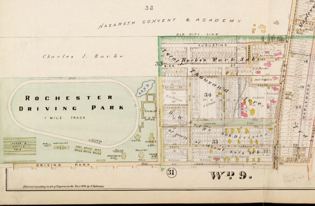
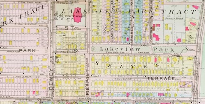
What years were plat maps published?: Civil engineers create plat maps and submit them to the City when properties are planned and approved, and new structures are built. Separate collections of these plat maps were therefore published when major developments were submitted and completed. The Local History & Genealogy Division has City of Rochester plat maps for the years 1875, 1888, 1900, 1910, 1918, 1926, and 1935. For plats older than 1875, contact the Rochester City Maps and Surveys Office, in City Hall (30 Church Street), Room 225B.
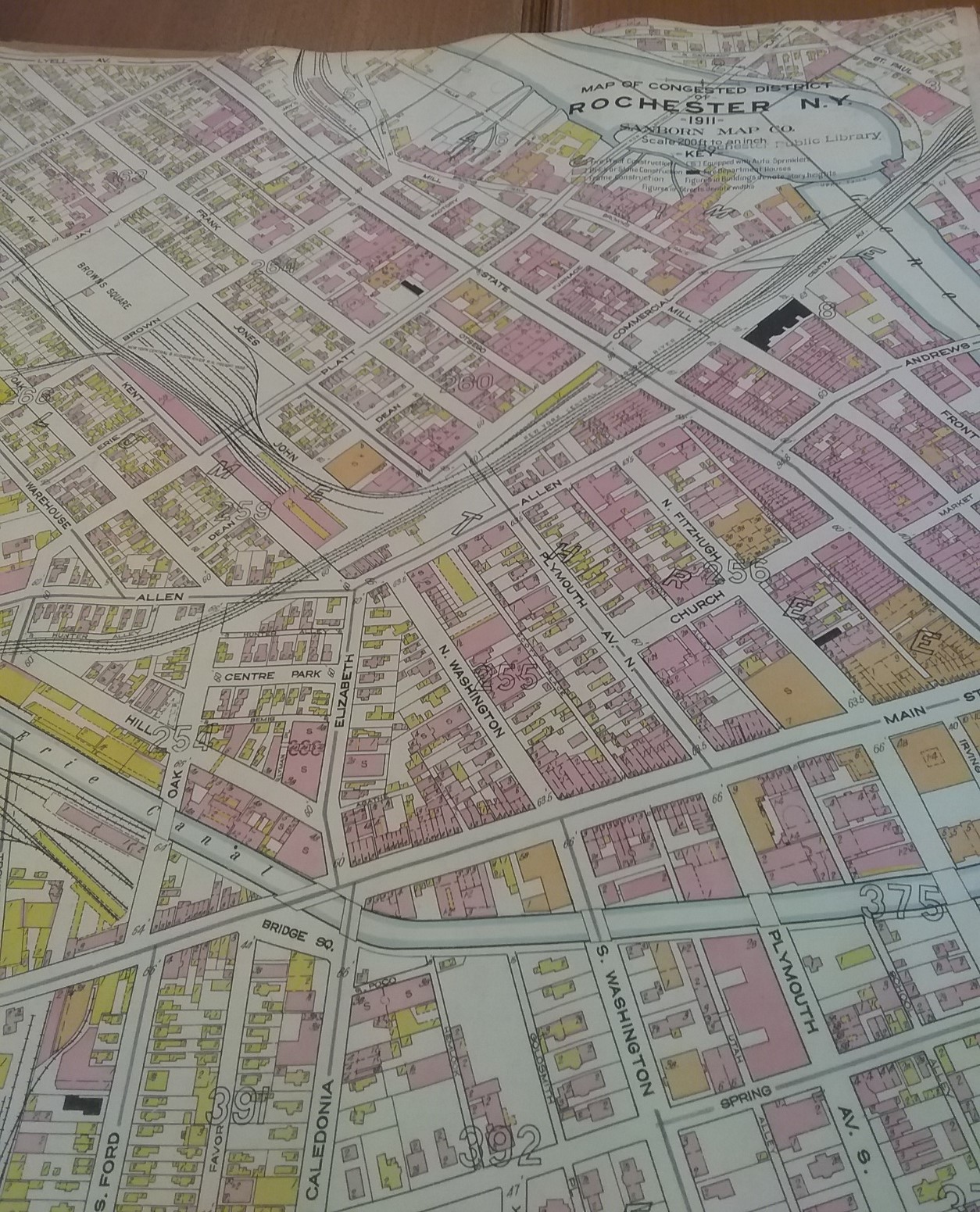
Does the library have similarly detailed maps that were published *after* 1935?: The Local History & Genealogy Division has a collection of Sanborn maps, which were created to help fire insurance companies assess their liability in urban areas. The Sanborn volumes were published at various times between 1911 and 1955. Unlike earlier plats, which published new volumes as neighborhoods changed, updated versions of Sanborn maps simply provided paste overlays to record changes to buildings and streets. A sample page from the 1911 Sanborn map follows:
Are there indexes to the plat and Sanborn maps? Yes. Check with library staff to locate these indexes.
What about maps of the towns? There are a limited number of plat maps in the division for suburban communities. The oldest is the 1902 map of Monroe County. The Sanborn maps include many of the suburban towns but are not exhaustive. Other plat maps exist for Pittsford (1924), Irondequoit and Brighton (1959), and Greece and Gates (1963). The Local History & Genealogy Division does not have plat maps printed after 1963. The division also has various maps of Monroe County from the nineteenth century, and while some feature the names of area property owners, they do not include the same level of detail as the plat maps.
Are there other resources other than maps to be consulted?: Yes!
1.Digitized newspapers. Searching an address in a digitized newspaper collection can turn up advertisements that involve the property or reporting of events that provide clues to ownership (e.g., burglaries, fires, etc…).
The library subscribes to the ProQuest Historical Newspapers: U.S. Northeast Collection, which includes the Democrat and Chronicle. City of Rochester residents can access the database here: https://roccitylibrary.org/division/local-history-genealogy/#databases and then enter the barcode on their library card and last name. Though remote access is not available for town residents, patrons can access the database in the library.

One free resource that imposes no such limitation is Fulton History. The owner of the site has digitized New York State newspapers, including many Rochester-area publications, from the nineteenth and twentieth centuries.
2. Land records. A useful resource outside the library, is the Monroe County Clerk’s Office (39 West Main Street, Room 105). The County Clerk’s Office maintains land records for the city and towns dating back to 1822. To find the deeds, which provide the details about land transfers, there are two sets of indexes, the Grantee Index and the Grantor Index.
The Grantee Index can be thought of as the “Buyer’s Index.” Once you’ve found a property owner’s name in the city or suburban directories, you can check the Grantee Index to determine exactly when the owner purchased it. The index will specify the buyer’s and seller’s names, as well as the volume and page number of the deed book in which the transaction is recorded. The Clerk’s staff will help you use the index and find the appropriate deed book on microfilm. The deed will record all parties to the transaction, the date thereof, the price for which it was sold, and the extent and boundaries of the property.
The Grantor Index can be thought of as the “Seller’s Index.” Should you want to know when a given owner sold a property, the index will help find the record. Like the Grantee Index, it will specify the seller, the buyer, and the volume and page number of the deed book. Retrieving the deed book and looking on the relevant page will take you to the property deed, which records all the information noted above. Going back and forth through the grantor and grantee indexes, and obtaining the right deeds, will provide a detailed chain of ownership for your historic home.
– Christopher Brennan


Leave a comment